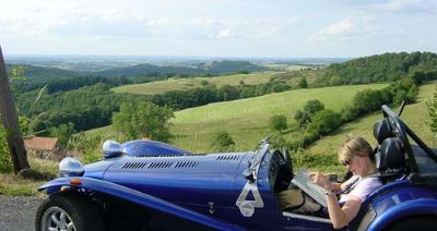
 As we headed east we left the flatish plains of the Loire region and into the Auvergne region, we started to drive into the hills. As we headed east we left the flatish plains of the Loire region and into the Auvergne region, we started to drive into the hills.
After leaving Loche we headed east - our only real plan was to head for the mountains, and maybe Switzerland. We travelled across the east of France pretty quickly and directly and decided to aim for Chamonix and Mont Blanc. This took us further south than we had expected but not by far, and anyway, we were determined to get to the mountains.
 Our 'best buy' was this map I saw in a motorway service station. A large scale map of France - but with plastic pages, so they could get wet and would be far better suited to fast open topped (and sides!) motoring. Our 'best buy' was this map I saw in a motorway service station. A large scale map of France - but with plastic pages, so they could get wet and would be far better suited to fast open topped (and sides!) motoring.
This map was a brilliant buy!! Before we got this we just had a small pocket map of France, meaning we generally kept to the larger roads until we got to somewhere we wanted to explore more closely, when we would usually stop at a local Tourist Information and pick up a more detailed local map. this large scale map meant that we could leave the main roads and stick entirely to the little local roads. these were invariably much more fun, often more direct and always almost empty. we stuck to roads with green lines next to them on the map, which meant a 'scenic' route.
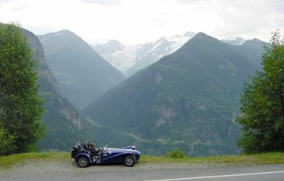
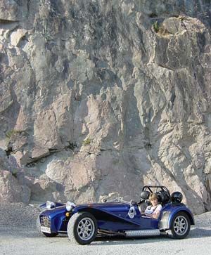 Quick stop in a roadside quarry for some photo opportunities - somewhere half way down a great twisty road somewhere in eastern France! From the Auvergne region we headed into Rhone-Alps - and the mountains!! Quick stop in a roadside quarry for some photo opportunities - somewhere half way down a great twisty road somewhere in eastern France! From the Auvergne region we headed into Rhone-Alps - and the mountains!!
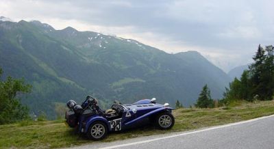
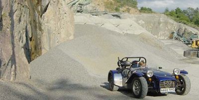 Biggest gravel trap I've ever been in! Biggest gravel trap I've ever been in!
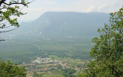 That quarry was somewhere half way down that hill in the distance! We had just come right over that, across the plain and were now going up the other side! That quarry was somewhere half way down that hill in the distance! We had just come right over that, across the plain and were now going up the other side!
The main routes in this region generally tended to be heading north/south - by taking the tiny roads we were able to travel almost directly east. These routes also took us straight up and straight down lots of big hills and small mountains (?!) where as the main roads tended to run up and down the valley floor in between the ranges. This meant that we had some of the best driving roads ever on this trip!
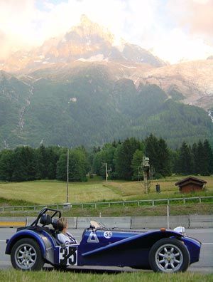 We arrived at Chamonix in the evening. Here we have stopped just near the entrance to the Mont Blanc tunnel. Above us in the evening sun you can see the Mont Blanc range, with the Glacier des Bossons coming down towards us. Arriving later in the day always adds pressure in finding somewhere to stay. After driving around the outskirts of the town looking at B&B's we decided to camp. Our new map had campsites marked, and the second one we looked at was perfect. We arrived at Chamonix in the evening. Here we have stopped just near the entrance to the Mont Blanc tunnel. Above us in the evening sun you can see the Mont Blanc range, with the Glacier des Bossons coming down towards us. Arriving later in the day always adds pressure in finding somewhere to stay. After driving around the outskirts of the town looking at B&B's we decided to camp. Our new map had campsites marked, and the second one we looked at was perfect.
 The Mont Blanc range. The Mont Blanc range.
 The campsite was about 2km outside Chamonix itself and brilliantly run with lots of care and attention to detail. The campsite was about 2km outside Chamonix itself and brilliantly run with lots of care and attention to detail.
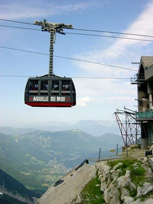
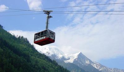 The next day we went into Chamonix and decided to use the cable car to go up the mountain range. The Aiguille du Midi cable car leaves almost from the centre of town. The next day we went into Chamonix and decided to use the cable car to go up the mountain range. The Aiguille du Midi cable car leaves almost from the centre of town.
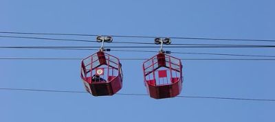
 Now I am not brilliant in cable cars. I look at that single little cable, those few guiding wheels, those big drops....this was the only pic I was able to take from in the car as I needed both hands to hold on! Now I am not brilliant in cable cars. I look at that single little cable, those few guiding wheels, those big drops....this was the only pic I was able to take from in the car as I needed both hands to hold on!
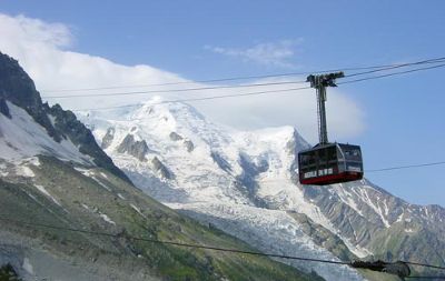
 The journey is in two stages. The first 8 minute run takes you to Plan de L'Aiguille. Now the next stage - another 8 minute ride, takes you much much higher and up to the top - Aiguille du Midi. I am not ashamed to admit I could not do this second ride!! The journey is in two stages. The first 8 minute run takes you to Plan de L'Aiguille. Now the next stage - another 8 minute ride, takes you much much higher and up to the top - Aiguille du Midi. I am not ashamed to admit I could not do this second ride!!
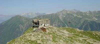 We walked up the mountain a little after the first cable car ride - this is looking back to the cable car station at Plan de L'Aiguille. We walked up the mountain a little after the first cable car ride - this is looking back to the cable car station at Plan de L'Aiguille.
 I guess these are maintenance cars/cages - nutters if you ask me! I guess these are maintenance cars/cages - nutters if you ask me!
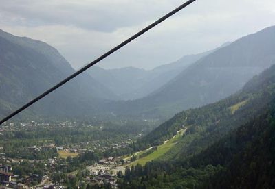
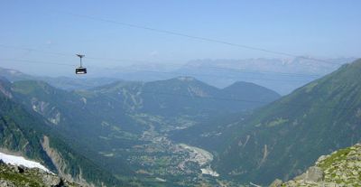
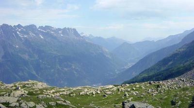 View across the valley and east towards Switzerland. View across the valley and east towards Switzerland.
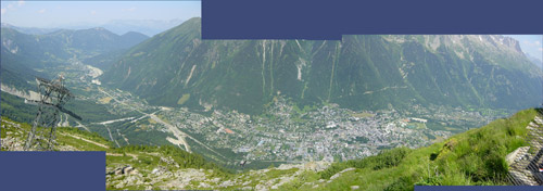 | | Montage looking down from Plan de L'Aiguille across to Le Brevent and over Chamonix itself. |
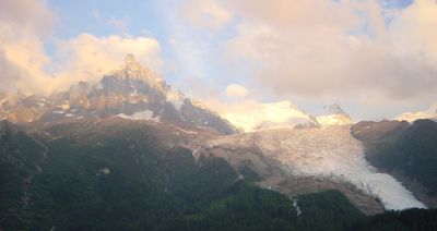
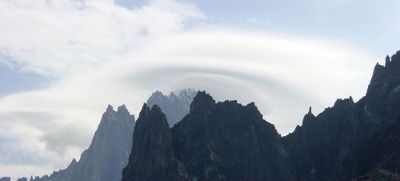 Great cloud formations formed over the peaks of the mountains as the moisture blew over. Great cloud formations formed over the peaks of the mountains as the moisture blew over.
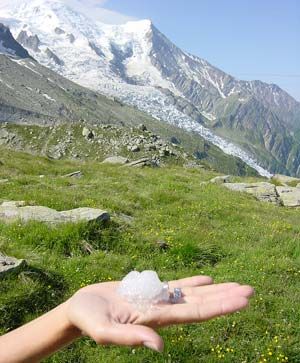 Despite the sun and the fact that we were only half way up, there was still snow around, which Tessa went to collect! Despite the sun and the fact that we were only half way up, there was still snow around, which Tessa went to collect!
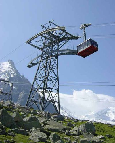
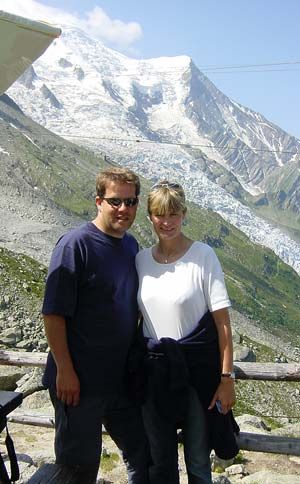 Proof that we made it at least this far! The Mont Blanc glacier is in the background, as are the cables for the final ride up to Aiguille du Midi. Apparently it is the highest cable car in the world, it peaks at 3842m. Proof that we made it at least this far! The Mont Blanc glacier is in the background, as are the cables for the final ride up to Aiguille du Midi. Apparently it is the highest cable car in the world, it peaks at 3842m.
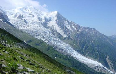 Better view of the Glacier des Bossons. Better view of the Glacier des Bossons.
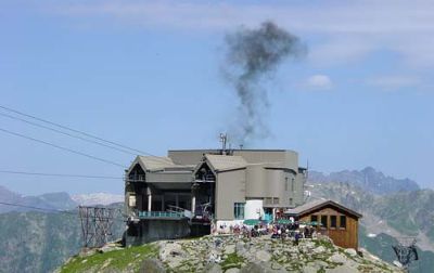 Everynow and again the cable car station would belch out a great billow of black smoke into the fresh mountain air. Probably a diesel - how French!! Everynow and again the cable car station would belch out a great billow of black smoke into the fresh mountain air. Probably a diesel - how French!!
 Another bunch of muppets - sorry, tourists - set off for the top. Now had this been a chair lift, I would probably have been ok. But a huge room full of about 80 people, all going 'ooooh' as the car swayed over the pylons was not my cup of tea at all. Trouble is, I really did want to go to the top - the view from that peak must have been amazing - to be twice as high as we already were, and to be able to look down into Italy - AND it was such a lovely clear day.... Another bunch of muppets - sorry, tourists - set off for the top. Now had this been a chair lift, I would probably have been ok. But a huge room full of about 80 people, all going 'ooooh' as the car swayed over the pylons was not my cup of tea at all. Trouble is, I really did want to go to the top - the view from that peak must have been amazing - to be twice as high as we already were, and to be able to look down into Italy - AND it was such a lovely clear day....
 Off they go... Off they go...
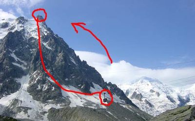 See how small the cable car looks - and see where it is heading - along one single span of cable.... See how small the cable car looks - and see where it is heading - along one single span of cable....
 I mean come on - you can't blame me surely!! I mean come on - you can't blame me surely!!
 Leaving Chamonix we were in Switzerland about 20 minutes down the road. Right away we left the main road and headed up a tiny zig-zag road up the mountain sides. Leaving Chamonix we were in Switzerland about 20 minutes down the road. Right away we left the main road and headed up a tiny zig-zag road up the mountain sides.
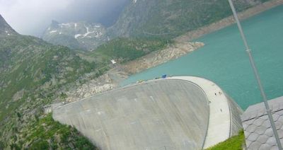 At the top was the 'Barrage d'Emosson' - a hydroelectric dam. Unfortunately just as we got to the top the clouds came down and it started to rain heavily, so we turned right around again... At the top was the 'Barrage d'Emosson' - a hydroelectric dam. Unfortunately just as we got to the top the clouds came down and it started to rain heavily, so we turned right around again...
 ...which was no big deal because it meant going back down the great road we had just come up! ...which was no big deal because it meant going back down the great road we had just come up!
 If you look very closely you can see some of the road we are about to go down in the trees as we head back down towards the valley floor. If you look very closely you can see some of the road we are about to go down in the trees as we head back down towards the valley floor.
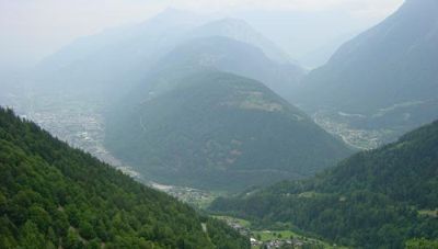
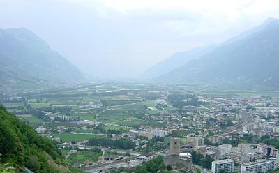 Heading down off the mountains towards Martigny. The fields here were growing apricots and other fruit, such as apples and pears. Obviously the micro-climate here was perfect - the foothills before hand were crammed with vines as well. Heading down off the mountains towards Martigny. The fields here were growing apricots and other fruit, such as apples and pears. Obviously the micro-climate here was perfect - the foothills before hand were crammed with vines as well.
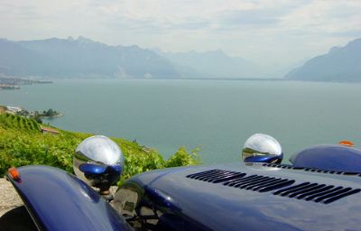
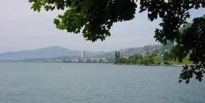 View from Villeneuve across 'Lac Leman' towards Montreux. I thought it was called 'Lake Geneve', but that is what it says on the map here! View from Villeneuve across 'Lac Leman' towards Montreux. I thought it was called 'Lake Geneve', but that is what it says on the map here!
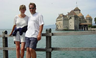 On the shores of the Lake, with Chateau de Chillon in the background. On the shores of the Lake, with Chateau de Chillon in the background.
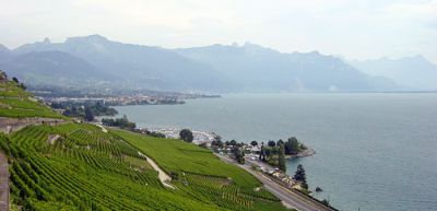 We drove around Montreux and headed away from the north shore of the lake. You can see all the vines facing south. We drove around Montreux and headed away from the north shore of the lake. You can see all the vines facing south.
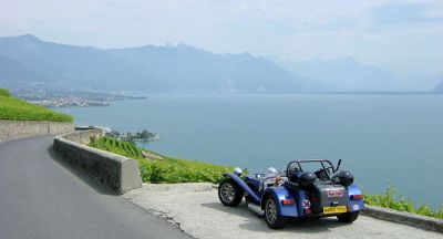 Just had to turn around and drive back to this location for a picture! Just had to turn around and drive back to this location for a picture!
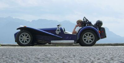
 Caterham at Lake Geneve. Caterham at Lake Geneve.
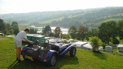 We headed north and around Lac de Neuchatel, past very crowded lake side campsites. Away from the tourist sites we found this site right on the border - across the water is France! We headed north and around Lac de Neuchatel, past very crowded lake side campsites. Away from the tourist sites we found this site right on the border - across the water is France!
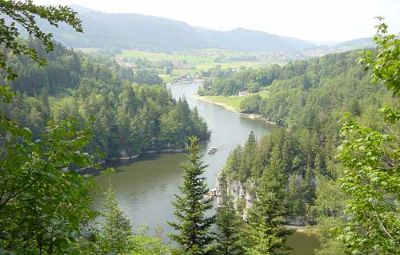 Campsite is top left in this pick - Switzerland on the left, France on the right. This was a nice walk along and above the Gorge. Campsite is top left in this pick - Switzerland on the left, France on the right. This was a nice walk along and above the Gorge.
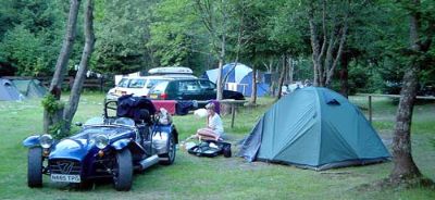
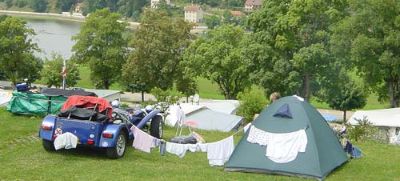 Camping Caterham style! Very nice facilities here so we stayed a few days - also meant we could watch the end of the Tour de France and the German GP on someones TV! Camping Caterham style! Very nice facilities here so we stayed a few days - also meant we could watch the end of the Tour de France and the German GP on someones TV!
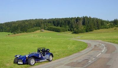 From the campsite we travelled along the Swiss/French border and into the Franche Comte region of France, and then north into Alsace. Twisty sweeping road typical of the region! From the campsite we travelled along the Swiss/French border and into the Franche Comte region of France, and then north into Alsace. Twisty sweeping road typical of the region!
|